Geospatial Technologies and Environmental Sustainability
Introduction
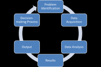
Have you ever used a GPS to get to an unknown location? Or used Google Earth to explore some far-off exotic place? If so, you have experience using geospatial technologies. Geospatial technologies, including geographic information systems (GIS), global positioning systems (GPS), and remote sensing are commonly used to research environmental sustainability issues over both spatial and temporal scales. These technologies are also used in both the public and private sectors to conduct a variety of research and analyses. This module is organized according to the six main phases of any geospatially related project. The module will deal with each of the six main phases in the order that they typically occur. These include:The focus of the content will be on how geospatially-related projects are completed, which will be demonstrated using some examples that are relevant to environmental sustainability. In addition, inputs on best practices and considerations when conducting your own project using geospatial technologies will be explored.
Learning Objectives
By the end of the module, you will be able to:- define and explain geospatial technologies;
- develop the knowledge and critical understanding of the key concepts, theories, methods, and current advances in geospatial technologies;
- describe and explain the application and use of geospatial technologies in addressing contemporary challenges in environmental sustainability; and
- develop knowledge of the research process; from problem identification and scope definition to data acquisition, data pre-processing and analysis, and the interpretation and presentation of results to facilitate decision-making processes in environmental sustainability.